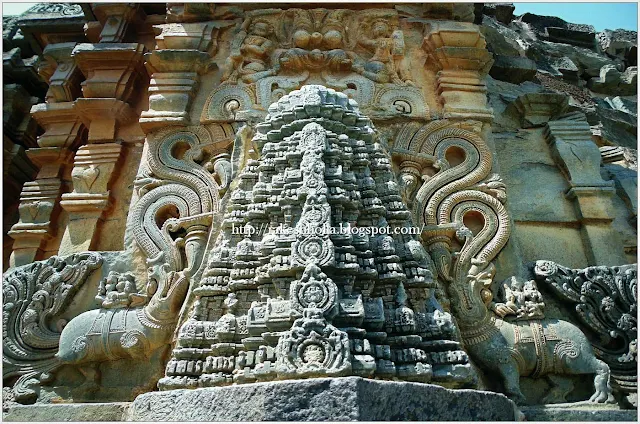
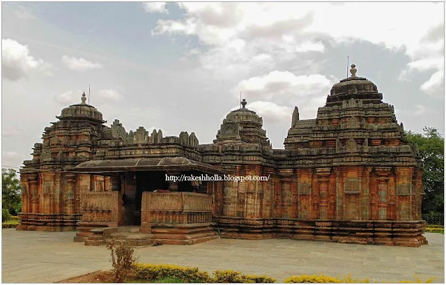
 The temple is situated on the bank of river Tungabhadera facing east
dedicated to Shiva assignable to 12th century of Kalyana
Chalukya king Vikramaditya VI, built of schist stone. Inspiration kept in the
temple, refers that Joyedevaras constructed the temple and granted lands for
the maintenance of this temple at Vikramapura. The name of the village is now
called Haralahalli. The earliest inscription found here refers to the rule of
the Guttas of Guttal. Their ruler Vikramaditya II was ruling under the
patronage of the Western Chalukyas. The Guttas were ruling from Guttavolal (modern
Guttal) which is not very far from this village. In comparison to Guttal,
Haralhalli seems to have more antiquities.
Photograph of the Someshvara Temple at Kanoda in Gujarat, taken by Henry Cousens in the 1880s. Of the temple at Kanoda, along the Rupen River in Gujarat, only the mandapa or columned hallway along with the foundations of the shrine exists. The undated temple’s mandapa consisted of three porches, covered by a domical roof decorated with brackets supporting figures of dancers and musicians. This temple is reproduced in collotype in Archaeological Survey of Western India, IX, 1903, pl. xii, described by Burgess and Cousens on pp. 110-11: “In the middle of the shrine lies a large stone head measuring 12.5 inches from chin to top of the forehead, looking like the head of a gigantic dwarapala; and beside it is a fragment with a devi sculptured on it.”
Photograph of the shrine of the Nageshwara temple at Kumbakonam, taken by Alexander Rea around 1892, from the Archaeological Survey of India Collections. Kumbakonam, in Tamil Nadu, was an important centre during the 9th to 13th centuries under the Chola dynasty. There are fifteen temples in the town dedicated both to Shiva and Vishnu. The Nageshwara Temple was erected in AD 886 during the Chola period, with later additions. The temple is situated in a courtyard entered through gopuras, or pyramidal towers, covered in sculptures, typical of the late Chola style. The outer walls of the sanctuary have sculptured panels which are among the finest of the Chola period.

Water-colour painting of a view from the Mess House of Poonamallee Fort by an unknown artist, dated to circa 1810. Inscribed on the front in pencil is: 'Poonamallee Fort from the Mess House.' Poonamallee, near Chennai (Madras) in Tamil Nadu, was formally a garrison town for the British Army containing a hospital and ordnance depot. The fort shown here is heavily fortified with battered high masonry walls and round projecting bastions.
Photograph from inside the north gopura of the Ramalingeshvara Temple at Rameswaram in Tamil Nadu, taken by Alexander Rea around 1890, from the Archaeological Survey of India Collections. This temple complex is situated on the sacred Hindu island of Rameswaram, connected to the mainland by a causeway. The site is believed to be related to the story of Rama of the Ramayana epic. It was founded during the Chola period but belongs mostly to the Nayaka period of the 17th and 18th centuries. The complex is contained within high walls entered through towered gopuras, or gateways, in the middle of the north, south and west sides. This is a view from inside the unfinished north gopura showing the road between the two halves of the wall.
Photograph of the ; part of a collection of albumen prints taken by Clarence Comyn Taylor between 1863-65, which constitute the earliest photographs of Nepal. Taylor, a soldier in the East India Company's army, was badly wounded in the Indian Uprising of 1857 and turned to Political Service, arriving in Kathmandu in 1863 as Assistant Resident. At this time the British had started a project to document the people and monuments of the Indian sub-continent using photography. Taylor fortuitously was a capable photographer and took images of Nepal for the Government of India. This image is described by Taylor in his List of pictures as, 'No XII. The golden gate in the Palace at Bhatgaon. It was put up by a Newar Rajah in 1754. The carvings above and on either side of the doorway represent Hindoo Deities symbols &c'.
The youngest of the three city-states of the Kathmandu Valley (the other two being Patan and Kathmandu), Bhaktapur grew in prominence from the 9th century AD, due to the opening of a new trans-Himalayan trade route. Like Kathmandu and Patan, it has a Darbar Square at its centre, endowed by succeeding kings with monuments both sacred and secular. The Golden Gateway (Sun Dhoka), covered with gilt-copper sculpture, was erected by Ranjit Malla in 1753-54 and dedicated to the goddess Taleju, the tutelary deity of the Mallas. At the centre of the metal gate or torana is an eight-headed and three-armed form of Taleju, above her is a heavy frame containing Garuda, Nagas or serpents and floral motifs. Running down either side of the door are figures of deities including a skeletal Kali, and in the top corners of the inner frame are two lifelike lizards. On either side of the Golden Gate are large copperplate inscriptions. The Panchapanna Jyale Darbar or 55 Window Palace is on the right and the shadow at the bottom right of the photograph is cast by the pillar portrait of Bhupatindra Malla.

Photograph of the base of the minaret of the Nagina Masjid at Champaner in Gujarat, taken by Henry Cousens in the 1880s for the Archaeological Survey of India. The ruined city of Champaner is situated north-east of Ahmadabad. It was a stronghold of Rajput kings until the Sultanate ruler Mahmud Begarha (r.1458-1511) took the city in 1484. Mahmud founded a new city at Champaner and moved his capital there. The Nagina Masjid, or Jewel Mosque, dates to the mid-16th century and is situated just north of the citadel. It has a similar plan but on a smaller scale to the Jami Masjid in the same city (1523), which was in turn modelled on the Jami Masjid at Ahmadabad (c.1424). This is a view of a carved stone niche at the base of
Rear view of the inlet sluice of the Khan Sarowar Tank, Patan - 1885
Photograph of the rear view of the inlet sluice of the Khan Sarowar Tank
at Patan in Gujarat, taken by Henry Cousens in the 1880s, from the
Archaeological Survey of India Collections. The Khan Sarowar tank was
the largest tank still in use in Patan when Cousens took this
photograph. There are stone steps that descend to the water and around
the edge of the tank there are pavilions. It was probably originally
constructed by the Solanki Kings when Patan was their capital in the
11th and 12th centuries. It was completely renovated in the late 16th
century by Khan I Azam Mirza Aziz Kokah, the governor of Gujarat under
the Mughal Emperor Akbar (r.1556-1605). The water for the tank passes
under a small bridge into a large, circular tank, and then through the
columns of a second bridge. The water then runs along a channel to
another large basin, then a masonry-lined channel which leads to a
sluice and finally to the tank itself.
Source : British Library
Photograph of a group of temples at Pattadakal in Karnataka, taken by Thomas Biggs in 1855, from 'Architecture in Dharwar and Mysore'. This photograph shows the Mallikarjuna Temple (c. 745), the Sangameshwara temple (early 8th century) and the Virupaksha Temple in the foreground (c. 745) and a temple car to the left foreground. Pattadakal, like neighbouring Aihole and Badami an important centre of the Chalukya dynasty, is located on the Malaprabha river in north Karnataka. The Chalukyas were a dynasty with different branches which ruled over parts of the Deccan (now in Karnataka, Maharashtra and Andhra Pradesh), in different periods. Pattadakal is believed to be the site where the coronation ceremonies of the Early Chalukya kings took place, between the 6th and 8th centuries. Nine temples, dedicated to Shiva and surrounded by minor shrines, line the west bank of the river, and a Jaina temple, from the later Rashtrakuta period, lies about a third of a mile away. The temples with their diverse styles represent the finest achievement of early Chalukyan architecture, and Pattadakal is now a World Heritage Site. Some of them are in the southern or dravida style and some display the northern or nagara style of temple architecture
Rear view of the inlet sluice of the Khan Sarowar Tank, Patan - 1885
Photograph of the rear view of the inlet sluice of the Khan Sarowar Tank
at Patan in Gujarat, taken by Henry Cousens in the 1880s, from the
Archaeological Survey of India Collections. The Khan Sarowar tank was
the largest tank still in use in Patan when Cousens took this
photograph. There are stone steps that descend to the water and around
the edge of the tank there are pavilions. It was probably originally
constructed by the Solanki Kings when Patan was their capital in the
11th and 12th centuries. It was completely renovated in the late 16th
century by Khan I Azam Mirza Aziz Kokah, the governor of Gujarat under
the Mughal Emperor Akbar (r.1556-1605). The water for the tank passes
under a small bridge into a large, circular tank, and then through the
columns of a second bridge. The water then runs along a channel to
another large basin, then a masonry-lined channel which leads to a
sluice and finally to the tank itself.
Source : British Library
Photograph of the rear view of the inlet sluice of the Khan Sarowar Tank at Patan in Gujarat, taken by Henry Cousens in the 1880s, from the Archaeological Survey of India Collections. The Khan Sarowar tank was the largest tank still in use in Patan when Cousens took this photograph. There are stone steps that descend to the water and around the edge of the tank there are pavilions. It was probably originally constructed by the Solanki Kings when Patan was their capital in the 11th and 12th centuries. It was completely renovated in the late 16th century by Khan I Azam Mirza Aziz Kokah, the governor of Gujarat under the Mughal Emperor Akbar (r.1556-1605). The water for the tank passes under a small bridge into a large, circular tank, and then through the columns of a second bridge. The water then runs along a channel to another large basin, then a masonry-lined channel which leads to a sluice and finally to the tank itself.
Bahusmarna temple ruins, Kanoda Gujarat


ReplyDeleteI like the way you start and then conclude your thoughts. Thanks for this nice information.
Best Packers and Movers near Poonamallee, Chennai
Hire tempo Traveller in faridabad, we are 10 years old company providing Tempo Traveller in faridabad,you can hire,rent tempo traveller for local or outstation tours.
ReplyDelete