INDIAN HISTORY THROUGH MAP- PART-V
(1) Valabhi / Valabhipura


- Vallabhi (modern Vala) is an ancient city located in Saurashtra peninsula near Bhavnagar. It was the capital of the ancient Maitraka dynasty.The Maitrakas came under the rule of Harsha in the mid-seventh century, but retained local autonomy, and regained their independence after Harsha’s death.
- Vallabhi was a noted center of the Jains. It was here in 466 AD that the Vallabhi council of the Jains produced in writing the religious canon (Jain Agams) under the leadership of the all Jain Acharya Shraman Devardhigani along with other 500 Jain Acharyas. The idols of each of them is present in the basement of the Jain temple here.
- However when the Chinese traveller Xuanzang visited Vallabhi during the second quarter of 7th century, he found its ruler to be a Buddhist follower. When Itsing, another Chinese traveller visited Vallabhi in the last quarter of 7th century, he found the city as a great center of learning Jainism including Buddhism.
- Gunamati and Sthiramati are stated to be two famous Buddhist scholars of Vallabhi at the middle of seventh century.
- Vallabhi was noted for its catholicity and the students from all over the country, including the Brahmana boys, visited it to have higher education in secular and religious subjects.
- Gajni or Gayni is one of the ancient names of port of Vallabhi (Cambay).
(3) Vasudevanallur

- In south India, the earliest iron objects appear in the overlap between neolithic and megalithic phases.
- Megaliths are widely distributed in South India. In Tamil Nadu, the sites include: Korkoi, Kayal, Kalugumalai, Perumalmalai, Pudukkotai, Tirukkampuliyar and Odugattur, Vasudevanallur, Achchnallur, Amritmangalam, Kunnattur, Sanur, Tenkasi
- Vasudevanallur Fort played role during Anglo-French-Mysire struggle.

- The recorded history of Vellore dates back to the ninth century, as seen from a Chola inscriptions in the Annamalaiyar Temple in Tiruvannamalai. After the rule of Cholas, it came under the Rashtrakutas, the later Cholas and Vijayanagar kings.
 |
| Jalagandeeswarar Temple |
- The Vellore Fort was built during the time of Chinna Bomma Nayak, a subordinate of Vijayanagar kings during the third quarter of the 16th century.The Fort’s ownership passed from Vijayanagara Kings, to the Bijapur Sultans, to Marathas, to the Carnatic Nawabs and finally to the British.The fort was constructed in granite. The fort houses a Temple, a Mosque and a Church, the renowned Vellore Christian Hospital. The Jalagandeeswarar Temple, dedicated to Jalagandeeswar, Shiva.
- During the 17th century, Vellore came under the dominion of the Nawab of the Carnatic.
(6) Vengi
- After the Mauryan Empire collapsed in 185 BC, the region was dominated by the Satavahanas, who were succeeded in Vengi by the Andhra Ikshvakus. Around 300, the Andhra Ikshvakus were replaced by the Salankayanas, who were vassals of the Pallavas. In the late 5th century, the Salankayanas were annexed by the Vishnukundinas.
- King Pulakesin II of the Chalukya conquered Vengi from the Vishnukundinas in the early 7th century and installed his brother Kubja Vishnuvardhana as the viceroy. He eventually established the Eastern Chalukya dynasty. The Eastern Chalukyas were first conquered by the Cholas under Raja Raja Chola I (985-1014). During the reign of the Kulothunga Chola I the Vengi kingdom got absorbed into the Chola empire.It later became part of Vijayanagar Empire.
- Eastern Chalukyas patronised Telugu. Since the time of the Eastern Chalukya Gunaga Vijayaditya, inscriptions show Telugu prose and poetry, culminating in the production of literary works. Later on, in the 11th century under the patronage of the then Vengi king, Rajaraja Narendra, the great epic, Mahabharata was translated partly by his court poet, Nannaya.

- Vengurla, being a safe and natural port, commercial centre was initially established during 1665 by Dutch traders and subsequently by British rulers.
(8) Vidisha

(10) Vikramashila (See Antichak in Part-A)
(11) Vilaspur (same as Bilaspur)
(12) Vilinam / Vizhinjam

- Vidisha is exceptionally rich in ancient monuments and historic places. A short distance to the north of the present town are the remains of the ancient town, known as Besnagar. Not far from Besnagar are the Udayagiri Caves with sculptures and inscriptions dating to the time of the Gupta Empire.
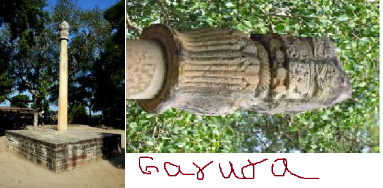
- Heliodorus pillar (Khamba Baba) is a monolithic free-standing column, the pillar bears an inscription which states that it was Garuda Pillar, raised in 140 BC in honour of Vasudeva by Heliodorous, a
resident of Taxila, who had been sent to the court of Bhagabhadra as an
envoy of Indo-Greek monarch. This inscription is a valuable historical
record, revealing both the relations that existed between the region and
the Greek kingdoms of the Punjab, and the fact that the Greek
ambassador had become a follower of Hindu god Vishnu.
- Bijamaṇḍal: Near the eastern edge of the old town are the remains of a large temple of the late Paramara period known as the Bijamaṇḍal. The building was started in the second half of the 11th century. On top of the plinth is a small mosque (of late 14th century) made using pillars; one pillar has an inscription of king Naravarman (1094-1134). It is a devotional inscription recording his reverence to Chamunda.
- Lohangi Pir: One of the most striking features of Vidisa is the prominent rock known as Lohangi Pir. With sheer cliffs on all sides, it towers over the town. The rock takes it name from a saint locally known as Lohaṅgi Pir.
- Sanchi: Just south of Vidisha is the ancient Buddhist complex of Sanchi. It flourished from the Maurya period until the end of Rajput rule. It was sometimes termed Vedisagiri, because of its closeness to Vidisha.

(10) Vikramashila (See Antichak in Part-A)
(11) Vilaspur (same as Bilaspur)
(12) Vilinam / Vizhinjam

- Vizhinjam is a locality of Thiruvananthapuram city in Kerala.850 AD – 1400 AD, the region was the scene of many battles between the Kulasekhara dynasty and the Later Cholas, and Vizhinjam, the then capital, was sacked by the Cholas.Vizhinjam had maritime trade with the Red Sea Coast during the early Christian Era (Roman period)
- Rajaraja Chola began his career by the conquest of the Chera country. He defeated Chera King Bhaskara Ravivarman, whose fleet he destroyed in the port of Kandalur. He also seized Pandya Amara Bhujanga and captured the port of Vilinam.
INDIAN HISTORY THROUGH MAP- PART-U
(1) Ucha


- On left bank of river Indus in Sind province of Pakistan.
- Frontier post during Delhi Sultanate. It remained a subject of constant threat and challenge for Balban, Alauddin Khalji and Md. Bin Tughlaq.
- Mongol seiged it in 1245 but were unsuccessful. Again during Alauddin Khalji, Mongol attack was unseccessful due to brilliant effort of Jafar Khan.
- In 1397, Timur Lung was successful in besieging and plundering it.
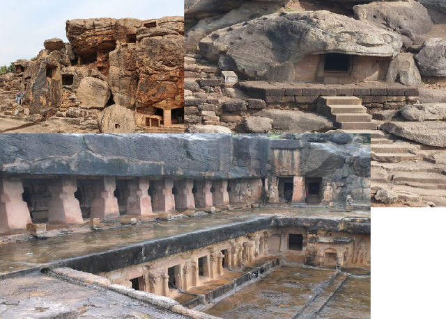
- The Udayagiri Caves (total 14) are located a short distance from ancient Besnagar, Udayagiri is about 4 km from the modern town of Vidisha and about 13 km from the Buddhist site of Sanchi.
- Udayagiri is best known for a series of rock-cut sanctuaries and images excavated into hillside in the early years of the fifth century CE.
- The site has important inscriptions of the Gupta dynasty belonging to the reigns of Chandragupta II (375-415) and Kumaragupta I (415-55).
- Udayagiri has a series of rock-shelters and petroglyphs, ruined buildings, inscriptions, water systems, fortifications and habitation mounds.
- There are a number of places in India with the same name, the most notable being the mountain called Udayagiri at Rajgir in Bihar and the Udayagiri and Khandagiri Caves in Odisha.
- The site at Udayagiri Caves was extensively reworked under the patronage of Candragupta II. Candragupta II did so in order to reflect a new concept of Hindu kingship, in which the monarch was seen as both the paramount sovereign (cakravartin) and the supreme devotee of the god Vishnu (paramabhagavata).
- Cave 4: It contains a Shiv Linga

- Cave 5 contains the much-celebrated figure of Vishnu in his Varaha
or Boar-headed incarnation.The depiction of Varaha symbolised the
unification of Northern India under the rule of Candragupta II. In this
way, it is said that Varaha’s rescue of the Earth from the chaos of the
cosmic sea echoed Chandragupta II’s rescue of Northern India from the
political instability and fragmentation that it had experienced prior to
the rise of the Gupta Empire.
- In Cave 6, on either side, are figures of Vishnu and of Shiva Gangadhara, the latter much worn from the falling of water over the image. Durga slaying the Buffalo Demon is one of the earliest representations of the theme in India and figure of seated Ganesha. Aside from this being the oldest datable Ganesa in India, the arrangement, with a guarded sanctum in the centre, Ganesha on one side and the mother goddesses on the other, presages the arrangement of temple space in subsequent centuries.
- Cave 8: Amongst all the Gupta inscriptions and antiquities, this is the only record that documents the actual presence of a Gupta king at a particular place.
- The Passage, which starts beside Cave 8, is a unique feature of Udayagiri.
It consists of a natural cleft or canyon in the rock running approximately east to west. The lowest set of steps on the right hand side is visibly water-worn and evidently served as a water-cascade in historic times. Shell inscriptions (so-called because of their shell-like shape) are engraved on the upper walls of the passage are the largest examples of this kind of writing known in India. The images of the fifth century cut through the Sankha Lipi indicating they pre-date Gupta times. Few sculptures present are mostly of standing Vishnu, all of which are damaged.
- Cave 12 consists of a niche containing a standing figure of Narasimha, Vishnu
in his ‘Lion-man’ incarnation. Below on either side are two small
standing attendant figures. In the floor below Narsimha there is a short
Brahmi inscription.
Narsimha and Ganesh - Cave 13 contains a figure of Narayana,
the figure of Vishnu resting. Beside the image of Narayana is a
kneeling devotee, and it has been argued that this figure is a depiction
of Chandragupta II himself, symbolising his devotion to Vishnu.


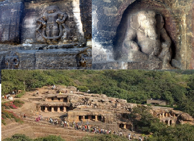
- Udayagiri and Khandagiri Caves are partly natural and partly artificial caves of archaeological, historical and religious importance near the city of Bhubaneswar in Odisha. The caves are situated on two adjacent hills, Udayagiri and Khandagiri, mentioned as Kumari Parvat in the Hathigumpha inscription. Udayagiri has 18 caves while Khandagiri has 15 caves. The art of Udayagiri and Khandagiri, being almost contemporaneous with that of Sanchi, has a striking resemblance to it but at the same time retains its own individuality and advanced technique.
- The caves of Udayagiri and Khandagiri, called lena in the inscriptions, were dug out mostly during the reign of Kharavela for the abode of Jaina ascetics. The most important of this group is Ranigumpha in Udayagiri which is a double storeyed monastery.
 |
| Udayagiri Caves |

- Khandagiri offers a fine view back over Bhubaneswar from its summit. The Ananta cave (cave 3) depicts carved figures of women, elephants, athletes, and geese carrying flowers.
Left top clockwise:1.Sarpagumpha, Udayagiri 2.Baghgumfa,Udayagiri(cave like snake mouth)3. Cave Monastery in Khandagiri - The Hathigumpha cave has the Hathigumpha inscription, written by Raja Kharavela, the king of Kalinga, during the 2nd century BCE. The Hathigumpha inscription incised in deep cut Brahmi letters. It faces the rock edicts of Ashoka at Dhauli, situated about six miles away.
- There are some other minor Brahmi inscriptions in the twin hillocks of Udayagiri and Khandagiri.
- Mancapuri cave inscription in Devanagari script
- Sarpagumpha cave inscription in Devanagari script.
- Anantgumpha inscription in Oriya.

(3) Udaipur
 |
| Udaipur |
- Udaipur was founded in 1559 by Maharana Udai Singh II as the shifting here the capital of Mewar kingdom from Chittorgarh. In November 1567, the Mughal emperor Akbar attacked & laid siege of the venerated fort of Chittor.
- As the Mughal empire weakened, the Sisodia ranas, and later maharanas (also called the Guhilots or Suryavansh), who had always tried to oppose Mughal dominance, reasserted their independence and recaptured most of Mewar except for Chittor. Udaipur remained the capital of the state, which became a princely state of British India in 1818. Being a mountainous region and unsuitable for heavily armoured Mughal horses, Udaipur remained safe from Mughal influence in spite of much pressure.

- By the 6th century BC, the large kingdom of Avanti, with its capital at Ujjaini, is mentioned in Buddhist literature as one of the four great powers along with Vatsa, Kosala and Magadha. The Northern black polished ware found their way to the northern Deccan from the Gangetic plains through Ujjain.
- The articles of export to the western Asia such as precious stones and pearls, scents and spices, perfumes, silks and muslin, reached the port of Brighukachcha from the remote north through Ujjain. All this finds description in the Periplus of the Erythrean Sea, an account of an unknown Greek merchant who made a voyage to India in the second half of the 1st century AD.
- The earliest known epigraphic record of the Paramaras, the Harsola Granth, issued at the beginning of the 10th century. The early Paramara chiefs of Malwa were probably vassals of the Rastrakutas. The Udaypur Prasati, mentions Vakpati I as the king of Avanti and it was probably in his region that the Rastrakuta Indra III halted at Ujjain while advancing with his army against the Pratihara Mahipala I.
- From the 9th to the 12th centuries, the Paramaras became so identified with Ujjain that subsequent tradition has converted Vikramaditya into a Paramara. The last Paramara ruler, Siladitya, was captured alive by the Sultans of Mandu, and Ujjain passed into the hands of the Muslims.
- Thus began a long era of misfortune and decay and the ancient glory of Ujjayini was lost in a morass of repeated inroads of attacking hordes. The invasion of Ujjain by Iltutmish in 1234 triggered off a systematic desecration and despoiling of temples. This tide of destruction was stemmed only in the time of Baz Bahadur of Mandu.
- The Mughal rule heralded a new era in reconstruction. Emperor Akbar put an end to Baz Bahadur’s hegemony over Malwa and had a city wall constructed for the defense of Ujjain.The Nadi Darwaza, Kaliadeh Darwaza, Sati Darwaza, Dewas Darwaza and Indore Darwaza were the various entrances to the city.
- In 1658 took place a battle near Ujjain in which Aurangzeb and Murad defeated Maharaja Jaswant Singh of Jodhpur, who was fighting on behalf of Prince Dara. The actual scene of the battle is Dharmatpura renamed Fatehbad by Aurangzeb, after the victory.
- In the reign of Mahmud Shah, Maharaja Sawai Jai Singh was made the Governor of Malwa. A great scholar of astronomy, he had the observatory at Ujjain reconstructed and built several temples.
- At the beginning of the 17th century, Ujjain and Malwa went through another period of seizure and invasion at the hands of the Marathas. The Maratha domination of Malwa gave impetus to a cultural renaissance in the region and modern Ujjain came into being. Most of the temples of Ujjain were constructed during this period.
- It was during this time that Ujjain became the meeting ground of painters of the Poona and Kangra styles.
- In the Maratha period, the art of wood work also developed. Wood carvings were done on the galleries and balconies.
- Ujjain finally passed into the hands of the Scindias in 1750 and until 1810, when Daulat Rao Scindia founded his new capital at Gwalior, it was the chief town of his dominions. The shifting of the capital to Gwalior led to a decline in the commercial importance of Ujjain.
- Ujjain enjoyed great importance in the battle for the empire and the constant struggle for supremacy. Political importance was compounded by the economic factor of Ujjain being situated on the main artery of trade between the North, the South and the West. This in turn contributed to Ujjain acquiring a cultural splendour of its own.
- The names of Kalidasa and Ujjayini are inextricably linked in Meghdoot, a poem describes the anguish of ayaksha, separated from his beloved by a curse.
- Aurangzeb gave numerous grants to temples belying tales of intense religious bigotry, which are preserved to this day by the families of the priests.
- A fragmented inscription of this place records the building of the palace in 1458, in the time of Mahmud Khilji. The tanks were constructed all around to keep the temperature very low by Sultan Nasiruddin Khilji, the Sultan of Malwa in the 16th century, because he was in the habit of taking mercury which is hot.
- Saivism, Vaishnavism and their various cults and sects, Jainism and Buddhism, have found a niche in this ancient city. The Siddha and the Natha cults which were offshoots of Tantricism, also flourished in Ujjain.
- The idol of Mahakaleshwar is known to be Dakshinamurti, facing the south. This is a unique feature upheld by tantric traditions to be found only in Mahakaleshwar among the 12 Jyotirlingas. The idol of Omkareshwar Shiva is consecrated in the sanctum above the Mahakal shrine. The images of Ganesh, Parvati and Karttikeya are installed in the west, north and east of the sanctum sanctorum. To the south is the image of Nandi. The idol of Nagchandreshwar on the third storey is open for darshan only on the day of Nag Panchami. On the day of Mahashivaratri, a huge fair is held near the temple and worship goes on through the night.
- Kumbh Mela is a mass Hindu pilgrimage of faith in which Hindus gather to bathe in a sacred river. It is held every third year at one of the four places by rotation: Haridwar, Allahabad (Prayaga), Nashik and Ujjain. Thus the Kumbh Mela is held at each of these four places every twelfth year. Ardha (“Half”) Kumbh Mela is held at only two places, Haridwar and Allahabad, every sixth year. The rivers at these four places are: the Ganges at Haridwar, the confluence of the Ganges and the Yamuna and the mythical Saraswati at Allahabad, the Godawari at Nashik, and the Shipra at Ujjain.

- Urayur is a neighborhood of Tiruchirapalli. It was the capital of the early Cholas with a fortress and city wall on the southern banks of the river Kaveri. This location is also known as Thirukkozhi, Nikalaapuri, Uranthai, and Kozhiyur. It has a history dating back to before 2 BCE.
- There is definite mention of the Cholas, whose founder was Vijayalaya and their capital in Ashokan inscriptions in Orissa. Inscriptions and rock edicts of Ashoka and the Satavahanas describes them.
- The Imperial Cholas of the 9th century CE later made Tanjavur their capital, and Urayur slowly lost its place in the Chola administration.
(6) Utnur


- Earliest neolithic site in south India (2900-2400 BCE): Utnur, Pallavoy, Kodekal, and Watgal.
- Utnur is in Mahbubnagar district in Telangana. Wooden enclosure of cattle pen here was rebuilt several times and dung within it was burnt repeatedly.The size of enclosure indicates that it could have held more than 500 cattle.
- Small amount of ground stone axes, stone blades and a handmade coarse pottery (burnished grey or buffed ware usually plain) found. Material culture of Utnur is similar to sites such as Piklihal (2100 BCE) and Kodekal.
(7) Uttaramerur / Uthiramerur / Uttiramerur


- Uttiramerur is located 35 km from Kanchipuram. It was ruled by the Pallavas, the Cholas, the Pandyas, the Sambuvarayars, the Vijayanagara Rayas and the Nayakas.
- It is known for its temples, built by the Pallavas and Cholas.The town is a home for one of the famous hindu temples called Uthiramerur Sundara Varada Perumal temple. This temple is about 1200 years old and is said to have been constructed under the palallava king Nandhi Varma Pallava. The main deity in this temple is Lord Sundara Varada Perumal. This temple has numerous inscriptions — those of the great Raja Raja Chola (985-1015 A.D.), his son, Rajendra Chola and the Vijayanagar emperor Krishnadevaraya.
- Stone edicts and carvings found in Uthiramerur have shown clues of local self governance during Chola imperial period. The elections were held by a method called Kudavolai. The edicts are called Uthiramerur Kalvettu after the place. On the walls of the village assembly (grama sabha mandapa), which was a rectangular structure made of granite slabs, are inscriptions saying that the village had an electoral system and a written constitution prescribing the mode of elections. This inscription, dated around 920 A.D. in the reign of Parantaka Chola.
- The Cholas divided their empire into convenient units for administration. Mandalam, kurram, nadu, perur, sirur were some of the local administration units. The provinces were governed by viceroy’s usually senior members of the royal family.
- It is the village administration which is mentioned specially and in great detail by Chola epigraphs. The two Uttaramerur inscriptions of the days of Parantaka I give detailed information regarding the functioning of the sabha, a Brahmin village.
- There were two kinds of autonomous villages known to Chola times. One was the village exclusively inhabited by Brahmins and called a sabha and the other was either mixed village or a completely non-brahmanical village called an Ur.
- Our information relates only to sabhas. It may be pure accident that all the inscriptions speaking of village autonomous institutions happen to be Brahmin villages; it may be that the Brahmins alone were interested in leaving permanent record of their public activities; or it may be that the Ur also was governed exactly like the sabha.
- The details of village administration one gets in the Uttaramerur inscriptions are anticipated in an earlier record found in the Pandyan country and known as the Manur inscription. The Brahmin settlements were called agraharas or chaturvedimangalams and they were ruled by a general assembly called the sabha.
- The Uttaramerur inscriptions record the resolutions of the sabha regarding the constitution of the Variyams or the committees.
- The village was divided into wards known as kudumbus. In a certain case the village consisted of 30 wards. Representatives of kudumbus made up the assembly.
- Qualification: Several qualifications were prescribed for membership of the committees. The qualifications related to ownership of property, residence in the locality, age between 35 and 70, well conversant with busines and virtuous and knowledge of the Vedas.
- Disqualification: If one had served previously on a committee during three preceding years it was a disqualification. Officials who had not submitted their accounts (their relatives will also get disqualified), sinners, guilty of incest, theft, taking bribes, who has taken forbidden dishes, were disqualified from office.
- Mode of Election: The names of persons nominated for selection out of the eligible list were written on strips of cudgeon leaves and these were put into a pot from out of which one would be extracted by a young boy.
- This was not election by ballot but selection by lot. The strip was called kudavolai. After the committees were so formed duties were assigned to them. Different committees were called the variyapperumakkal.
- Annual Committee (most learned men), Garden committee, Tank Committee (It will oversee irrigation). The last two committees shall be chosen by showing the Karai(lot). Men of these three committees shall hold office for one year and then retire.
- Panchavara Committees and Gold Committees will be selected by lot from pot method.
- Removal of Persons Found Guilty: When one who is on the committee is found guilty of any offence, he shall be removed. To fill the vacancy, the members of the Committee “for Supervision of Justice” shall convene an assembly kuri with the help of the Arbitrator. The committees shall be appointed by drawing pot-tickets.
- Qualification of the Accountant: Any Arbitrator who possesses honest earnings shall write the accounts of the village.
- King’s Order: As long as the moon and the sun endure, committees shall always be appointed by pot-tickets alone. To this effect was the royal letter received and shown to us graciously issued by Lord of Gods, the emperor, the glorious Parakesarivarman.
- Officer Present: Royal officer will be present while making settlements.
- Villager’s Decision: We, the members of the assembly of Uttaramerur Chaturvedimangalam, made this settlement for the prosperity of our village in order that wicked men may perish and the rest may prosper.
INDIAN HISTORY THROUGH MAP- PART-A
(1) Adamgarh
- Adamgarh Hills is located in the Hoshangabad district in Madhya Pradesh.
- Adamgarh Hills are famous for the pre-historic rock shelters and paintings found in the hills.
- Stone age artefacts, lower palaeolithic and Meolithic implements have been excavated here.
(2) Adichanallur
- Adichanallur is an archaeological sites located on the right bank of the Tambraparani River, in the Tuticorin District (formerly Tirunelveli) of Tamil Nadu.
- The extensive urn burial site at Adichchanallur. A number of skeletons dating from around 3,800 years ago were found buried in earthenware urns.
- Bronze objects, iron objects besides thousands of potsherds. Sherds were also found with writing in Tamil Scripts (500-300 BC)
- The burials have been classified into three phases, viz., Phase I, II and III. This three-tier burial system was discovered in which earlier generations were buried in urns at 10 feet depth and recent ones above them.
- Phase I contains predominantly primary burials, while in Phases II & III, both primary and secondary burials are found.
 |
| Urn burials in Situ |
- The skeletal remains inside the urns are invariably placed in crouched position. No orientation seems to have been followed. There are two examples of double burial. A potsherd with applique narrative (A decorative design made of one material sewn over another) scene is an important find. Good number of graffiti on pottery has been discovered.
 |
| Contents of an Urn burial: Remains of bones and burial goods in situ |
- Pottery types include black and red ware, red ware and black ware.
- Iron implements like arrowheads, spearheads and axe are found. Few copper ornaments have also been found. Rice husk and cloth impression has been found on one of the Iron sword. A potter’s kiln (industrial activity) was also exposed in the habitational site.
- Korkai the capital of the Early Pandyan Kingdom is located about 15 km from Adichanallur.

- Agiabir is located on the left bank of river Ganga in district Mirzapur of eastern Utter Pradesh.
- The ancient settlements extend in an area of more than one km along the river. Five periods cultural sequence from 1300 BC to 700 AD .
- Long cultural sequence extending from Narhan Phase to early medieval period.
- Period 1 (Narhan Cultural phase): Pottery BRW, black slipped ware and red ware. Pottery showed some difference from Narhan. People lived in wattle-and-daub huts and silos used for storing grains. Agate beads, a bead making workshop, terracotta beads, microliths, bone points, copper fishhook, clay lamp. Fireplaces associated with charred animals give idea of food habits.
- Period 2 is pre-NBP with iron.
- The habitation of remains of period fifth belonged to the Gupta and post-Gupta times. The house complex of 11 rooms with courtyard and a boundary wall found. The remains of a temple complex ( temples with Krishna)

- Sikandar Lodi, the Ruler of the Delhi Sultanate founded Agra in the year 1504.
- The golden age of the city began with the Mughals. It was known then as Akbarabad and remained the capital of the Mughal Empire under the Emperors Akbar, Jahangir and Shah Jahan. Shah Jahan later shifted his capital to Shahjahanabad (Delhi) in the year 1638.
- Babar laid out the first formal Persian garden on the banks of river Yamuna. The garden is called the Aram Bagh. Akbar raised the towering ramparts of the Great Red Fort, besides making Agra a center for learning, arts, commerce and religion.
- Akbar also built a new city on the outskirts of Akbarabad called Fatehpur Sikri.His son Jahangir had a love of gardens and flora and fauna and laid many gardens inside the Red Fort. Shah Jahan, known for his keen interest in architecture, gave Akbarabad the Taj Mahal. Built in loving memory of his wife Mumtaz Mahal, the mausoleum was completed in 1653.
- Shah Jahan later shifted the capital to Delhi during his reign, but his son Aurangzeb moved the capital back to Akbarabad.
- Akbarabad remained the capital of India during the rule of Aurangzeb until he shifted it to Aurangabad in the Deccan in 1653. After the decline of the Mughal Empire, the city came under the influence of Marathas and was called Agra, before falling into the hands of the British Raj in 1803.
 |
| Ahar-Banas Culture Sites—-Red: Ahar, Blue: Balthal, Green: Gilund, Black:Ojiyana |

- The Ahar culture or Banas culture is a Chalcolithic culture of southeastern Rajasthan lasting from 3000 to 1500 BCE, contemporary and adjacent to the Indus Valley Civilization. Situated along the Banas and Berach Rivers, the Ahar-Banas people were exploiting the copper ores of the Aravalli Range to make axes and other artefacts. They were sustained on a number of crops, including wheat and barley.
- Over 90 sites of Ahar or Banas culture have been identified in south-east Rajasthan in the Banas and berach river systems (Between Udaipur and jaipur). Some sites are also in Malwa plateau, MP. Ahar, Gilund, Balathal are three excavated sites. Sites of Ahar culture show the use of a great variety of raw materials including steatite, shell, agate, jasper, lapis lazuli, copper, blonze. Shell objects were locally made but shell came from gujarat coast.The discovery of carnelian beads, a lapiz lazuli bead, and Rangpur type lustrous red ware suggests connection with harappan sites in Gujarat.
- Typical Ahar pottery is a Black-and-Red ware (BRW) with linear and dotted designs painted on it in white pigment and has limited range of shapes, which include bowls, bowls-on-stands, elongated vases and globular vases. The Ahar culture also had equally distinctive brightly slipped Red Ware, a Tan ware, ceramics in Burnished Black that were incised Thin Red ware, as well as incised and otherwise decorated Gray ware fabrics.The pottery had a black top and reddish bottom, with paintings in white on the black surface.
- Because of these distinctive features, Ahar, was called the “black and red ware culture“. The pottery used by the inhabitants of Ahar for drinking and eating.
- Discoveries at Gilund were broadly similar to Ahar.

- Ahichatra was the ancient capital of Northern Panchala. The remains of this city has been discovered near Ramnagar village of Bareilly district in Uttar Pradesh.
- A brick fortification and continuity of occupation from a period before 600 BCE to 1100 CE.
- Four cultural periods named as Period I to IV starting from Ochre Coloured Pottery (OCP). It was first inhabited by the middle of the second millennium BC with Ochre Coloured Pottery culture people, followed by Black and Red Ware culture.
- Around 1000 BC, it became one of the largest Painted Grey Ware culture sites.
- PGW followed by NBPW up to Kusana Gupta period.
(7) Ahmadnagar

- Ahmednagar was founded in 1490 by Ahmad Nizam Shah. With the breakup of the Bahmani Sultanate, Ahmad established a new sultanate in Ahmednagar, also known as Nizam Shahi dynasty.
- It lasted until its conquest by Mughal emperor Shah Jahan in 1636. Aurangzeb died in Ahmednagar and his burial at (khultabad) near Aurangabad in 1707.
- Maharani Ahilyabai Holkar was born on 31 May 1725 in Ahmednagar district.
- In 1759, the Peshwa of the Marathas obtained possession of the place from Nizam of Hyderabad and in 1795 it was ceded by the Peshwa to the Maratha chief Daulat Rao Sindhia. Ahmednagar was invaded by a British force under General Wellesley and captured. It was afterwards restored to the Marathas, but again came into the possession of the British in 1817, according to the terms of the Treaty of Poona.
(8) Ahmedabad /Ahmadabad

- The area around Ahmedabad has been inhabited since the 11th century, when it was known as Ashaval or Ashapalli. At that time, Karandev I, the Solanki ruler of Anhilwara (modern Patan), waged a successful war against the Bhil king of Ashaval, and established a city called Karnavati on the banks of the Sabarmati.
- Solanki rule lasted until the 13th century, when Gujarat came under the control of the Vaghela dynasty of Dholka.
- Gujarat subsequently came under the control of the Delhi Sultanate in the 14th century. However, by the earlier 15th century, the local governor Zafar Khan Muzaffar established his independence from the Delhi Sultanate and crowned himself Sultan of Gujarat as Muzaffar Shah I, thereby founding the Muzaffarid dynasty. This area finally came under the control of his grandson Sultan Ahmed Shah in 1411 A.D. who for a new capital city and laid the foundation of a new walled city near Karnavati and named it Ahmedabad.
- In 1487, Mahmud Begada, the grandson of Ahmed Shah, fortified the city.
- In 1535 Humayun briefly occupied Ahmedabad after capturing Champaner when the ruler of Gujarat, Bahadur Shah, fled to Diu. Ahmedabad was then reoccupied by the Muzaffarid dynasty until 1573 when Gujarat was conquered by Akbar.
- During the Mughal reign, Ahmedabad became one of the Empire’s thriving centres of trade, mainly in textiles, which were exported as far as Europe. Shahjahan sponsored the construction of the Moti Shahi Mahal in Shahibaug.
- Ahmedabad remained the provincial headquarters of the Mughals until 1758, when they surrendered the city to the Marathas.

- Ajmer is surrounded by the Aravalli Mountains. It is a pilgrimage centre for the shrine of the Sufi Saint Khwaja Moinuddin Chishti and is also the base for visiting Pushkar (11 km), an ancient Hindu pilgrimage city, famous for the temple of Brahma.
- Ajmer (Ajaya meru meaning “Invincible Spine”) was founded in the late 7th century A.D. by Ajayraj Singh Chauhan. The Chauhan dynasty ruled Ajmer in spite of repeated invasions by Turkic Muslim armies from Central Asia.
- Ajmer was conquered by Muhammad Ghori in 1193.
- Ajmer regained independence under the ruler of Mewar in 1365.
- In 1509, control of Ajmer was disputed between the Maharajas of Mewar and Marwar until it was conquered by the Marwar in 1532.
- In 1553, the state was ruled by the Hindu Emperor Hem Chandra Vikramaditya, popularly known as Hemu, who was killed in 1556 in the Second Battle of Panipat. The city was conquered by the Mughal emperor Akbar in 1559. In the early 1700s century, control passed to the Marathas.
(10) Akhnur

- Akhnoor is an archeological site at a distance of 28 km from Jammu.The town is located on the banks of the Chenab River.
- Akhnoor was one of the last bastion of the Harappan Civilization. Manda (Akhnoor) is the northern most site of the Harrappan Civilisation. Terracotta figures and other anthropological objects belonging to the later Harrappan period have been found.
- Excavations at Ambaran-Pamberwan sites have proved that the place was a prominent abode of Buddhism during the Kushan period and Gupta period. Apart from an ancient Stupa, life sized Terracotta busts of Buddha and coins belonging to those periods were also excavated from the sites.
- Buddhist relics from the Pre-Kushan reign and silver caskets, gold and silver leaves, pearls, corals and three copper coins from the Gupta period are found.
- The location of the Stupas is such that it lies on the ancient routes from Pataliputra to Taxila.
- Hinduism: Trimurti idol made up of a single stone found at Ambarran Village.

- Alamgirpur is an archeological site of the Indus Valley Civilization located in Meerut district, Uttar Pradesh.
- It is the eastern most site of the civilization.This site was also called Parasaram-ka-khera.
- Typical Harappan pottery was found and the complex itself appeared to be a pottery workshop.
- Ceramic items found included roof tiles, dishes, cups, cubicle dice, beads, terrecotta cakes, carts and figurines of a humped bull and a snake.There were also beads and possibly ear studs made of steatite paste, faience, glass, carnelian, quartz, agate and black jasper. A broken blade made of copper was found.
- A small terrecotta bead-like structure was coated with gold.
- Evidence of cloth is found; yarn used for cloth looked fairly fine and weaving method used is “plain weave“.
- Four periods of Alamgirpur respectively belonged to (I) Harappan, (II) Painted Grey Ware (III) Early historical and (IV) Late Medieval Period.
(12) Allahabad (Prayag) ,Kaushambi


- Excavations have revealed Northern Black Polished Ware dating to 600–700 BCE.
- When the Aryans first settled in what they called the Aryavarta (or Madhyadesha), Prayag (then Kaushambi) was an important part of their territory. The Kurus, rulers of Hastinapur (near Delhi), established the town of Kaushambi near Prayag.They shifted their capital to Kaushambi when Hastinapur was destroyed by floods.
- The Doab region, which includes Allahabad, was controlled by a succession of empires and dynasties.The area became part of the Mauryan and Gupta Empires from the east and the Kushan Empire from the west before being governed by Kannauj during the 15th century.
- Prayag became a part of the Delhi Sultanate when it was annexed by Mohammad Ghori in 1193. Later, the Mughals took over. Akbar built a fort on the banks of the sangam and renamed the settlement Ilahabad (Persian for “place of a god”) in 1575.
(13) Alwar

- Maharaja Alaghraj, second son of Maharaja Kakil of Amer (old seat of Jaipur state) ruled the area in the eleventh century and his territory extended up to the present city of Alwar. He founded the city of Alwar.
- The princely state of Alwar was ruled by Pratap Singh, a Rajput of the Kachwaha lineage, in 1770.

- In Guntur District of Andhra Pradesh
- The recorded history of Amaravati and nearby Dharanikota dates to 2nd century BCE. It was the capital of Satavahanas (2nd century BCE to 3rd century CE).
- After the decline of Satavahanas, Andhra Ikshvakus and later Pallava kings ruled Krishna river valley. Subsequently, Eastern Chalukyas and Telugu Cholas held sway over the region.
- The stupa: The region between Krishna and Godavari rivers was an important place for Buddhism from the 2nd century BCE with Amaravati being one of them. Buddhist stupa was built during the reign of Ashoka in 200 BCE, was carved with panels that tells the story of Buddha. During the period of the decline of Buddhism, this stupa was also neglected. The stupa is related to the Vajrayana teachings of Kalachakra, still practiced today in Tibetan Buddhism.
- Ancient School of Arts: Amaravati art was as one of the three major styles or schools of ancient Indian art, the other two being the Gandhara style and the Mathura style. Some of the Buddhist sculptures of Amaravati betray a Greco-Roman influence that was the direct result of the close trade and diplomatic contacts between South India and the ancient Romans. Amaravati has itself yielded a few Roman coins.
- Amaravati art form evolved and flourished for nearly six centuries commencing from 200-100 BC. Patronized first by the Satavahanas and later by the Ikshvakus .With its beginning in 3rd century BC the Amaravati unfolds its chapters through the galaxy of sculptural wealth that once adorned the Mahachaitya, the majestic monument of the Buddhists situated here.
- Chinese traveller Hiuen Tsang visited Amaravati in 640 CE, He wrote a glorious account of the place, Viharas and monasteries that existed.

- It is in Sindh, Pakistan. Amarkot was the capital of Greater Sindh Province, including some parts of the present Rajasthan.This province was ruled by one of the subclan of Paramara Rajputs .
- Mughal king Akbar was born in Umerkot when his father Humayun fled from military defeat at the hands of Sher Shah Suri. Rana Prasad, a Hindu Sodha Rajput ruler of Amarkot, gave refuge to Humayun.
- Umerkot is one of the few provinces that has never been conquered by any invader, including Mughals.
(16) Amber/Amer ( Now Jaipur)

- Around 1037 A.D., Amer was conquered by the Kachwaha clan of Rajputs. Much of the present structure known as Amer Fort is actually the palace built by Raja Man Singh who ruled from 1590-1614 A.D. The palace contains several buildings, such as the Diwan-i-Khas, and the elaborately painted Ganesh Poll built by Mirza Raja Jai Singh I (Man Singh I’s grandson).
- The old and original fort of Amer, dating from earlier Rajas is known in the present day as Jaigarh Fort.
- Amer was capital of the Kachwahas until 1727 when the ruler of Amer Sawai Jai Singh II founded a capital Jainagara (Jaipur), named after him, about nine kilometers south of Amer.
(17) Amarkantak

- Amarkantak is a pilgrim town Anuppur District in MP. Also called “Teerthraj” (the king of pilgrimages), Amarkantak region is the meeting point of the Vindhyas and the Satpuras, with the Maikal Hills being the fulcrum. This is where the Narmada River, the Son River and Johila River emerge.
- Adi Shankarachrya was born in 788 and consecrated on the banks of Narmada River. He founded Pataleshwar Mahadev in Amarkantak at the origin of Narmada.
- The Kalchuri Maharaja Karnadeva (1042–1072 AD) had constructed temples at Surajkund.
(18) Amri

- Amri is an ancient settlement in Sindh province of Pakistan.The site is located south of MohenjoDaro about 110 kilometres north of Hyderabad.
- Pre-Harappan stage:The earliest phase was a fortified town which flourished from 3600 to 3300 BC, and belonged to the Pre-Harappan stage of the Indus Valley Civilization.
- Amri is close to Balochistan where development of earlier farming communities from 6000BC to 4000BC ultimately led to urbanization.
- The ancient mounds of 8 hectares on the west bank of Indus River have been extensively excavated. The pottery discovered here had its own characteristics and known as Amri Ware. Like other Pre Harappa towns, no writings were found at this site. There is evidence of widespread fire at the town around 2500BC.
- Later phases: In period II (2750-2450 BC), more and more elements of the Indus Valley culture appear.
- Period III (2450-1900 BC) belongs almost entirely to Indus Valley culture.
- Period IV (1900-1300 BC) is marked by the mingling of cultural layers. Elements of the Jhukar culture appear, and co-exist with the last phase of the Indus Valley culture. Later, the elements of the Jhangar culture also appear.
- Based on the evidence from this site, it is believed that the Indus culture was probably not developed directly from the Amri culture.
(19) Amritsar

- Amritsar was named after the lake founded by the fourth Sikh Guru Ram Das in 1574. Earlier, Guru Ram Das had begun building Santokhsar Sarovar.
- It is home to the Harmandir Sahib (Golden Temple), the spiritual and cultural center for the Sikh religion.The city also houses the Sikh temporal and political authority, Akal Takht, as well as the Sikh Parliament.
- The city lies on the main Grand Trunk Road (GT Road) from Delhi to Amritsar connecting to Lahore in Pakistan.

- It is in Faridabad district and along with Mehrauli and Tugluqabad it constitutes the triangle of historical importance in Delhi. Tugluqabad was the Centre of Delhi during the reign of Mohd Bin Tagluq and Mehrauli is believed to be the place where the first Delhi was created. Anangpur was founded by Raja Anangpal and Prithvi Raj Chauhan lived here.
- The people of the village are helping in creating a replica of Hariparbat on one of the hillocks on the boundary of the village with a temple of goddess Sharika on the top, as a token of solidarity with the displaced Kashmiri Pandits.
(21) Anegondi /Anegundi

- Pre-historic: Several Neolithic dwellings still bear paintings. This is the rare human settlement where we will find traces of Microlithic, Megalithic and Neolithic age of human life at one same spot. The nearest Pre-historic sites are Hire Benekal, Chikkarampur, Mallapur, Venkatapur and Anjanahalli. Pre-historic rock shelters and paintings are found in Tungabhadra river valley.
- Rock art: The boulders with rock art, a rock with some red and white markings had figures of human and bull. On another boulder there is a circular diagram like sun and moon and with some symbolism. Actually the rock painting belonged to Iron Age, date back to 1500 BC and the faded circular painting, a very rare depiction of a megalithic style of burial, also includes a human body in the middle surrounded by a stone circle and burial goods. The site of megalithic dolmens located up in the hills, about five to seven feet high sheet rocks forms four walls and another rock sheet used as roof (Neolithic period), it is about 10 km away from Anegundi. About 1.5 km from Anegundi, there are rock shelters and paintings.
- The first capital of Vijayanagar Empire. In 1334, Deva Raya the Chief Minister of Anegundi became ruler of Anegundi. When Delhi Sultans invaded Warangal, Harihara and Bukka escaped and came to Anegundi, later founded the Vijayanagar Empire at Hampi.
- During 16th, 17th and 18th centuries, Anegundi was ruled by Bijapur Sultans, Moghuls, Marathas and Tipu Sultan.
- Anegundi has Fort with a Durga temple and a Ganesha cave temple. Vijayanagar kings they use to pray before every battle at Durga temple, then they visit Pampa Sarovar and Lakshmi temple.
(22) Anga

- Anga was a kingdom that flourished on the eastern Indian subcontinent in the 6th century BCE until taken over by Magadha in the same century. Counted among the “Sixteen Mahajanapada” in Buddhist texts like the Anguttara Nikaya, Anga also finds mention in the Jain Vyakhyaprajnapti’s list of ancient janapadas.
- Between the Vatsas and the realm of Anga, lived the Magadhas. A great struggle went on between the Angas and its eastern neighbors. About the middle of 6th century BC, Bimbisara, the crown prince of Magadha had killed Brahmadatta, the last independent king of Anga and seized Champa. Thenceforth, Anga became an integral part of growing Magadha empire .
- The capital of Anga was Champa (Campa), located on the right bank of river Ganges near its junction with river Champa. Bhagalpur in Bihar, usually identified as the site of Champa, still has two villages called Champa-nagara and Champa-pura

- It is in Orissa. The temple of Budhi Thakurani and Jagannath Temple is situated here.
(24) Ambari (See location of Guwahati in Part-G)
- Located North West of Guwahati, it is a site for important archaeological excavations related to ancient Assam.
(26) Anhilwad / Patan / Lalitpatan:


- Patan, an ancient fortified town, was founded in 745 AD by Vanraj Chavda, of the Chavda Kingdom. He named the city Anhilpur Patan or “Anhilwad Patan”
- Later Mulraj, the adopted son of last Chavda king, established Solanki dynasty. He successfully expanded kingdom to west. Solanki rule cover Saurashtra and Kutch in the West, Lata in the South, Malwa in the East and Southern Rajasthan in the North at its greatest period.
- When Muhammad Ghori had attempted to conquer Gujarat, the forces of Mularaja II, then the king of Patan, a mere boy-ruler, led by his heroic mother Naikidevi, inflicted such a crushing and conclusive defeat on him that he never again entered India through Gujarat.
- Muhammed’s general and later Sultan of Delhi Qutb-ud-din Aybak sacked the city between 1200 and 1210, and it was destroyed by the Alladin Khilji in 1298.
- The modern town of Patan later sprung up near the ruins of Anhilwara. During 1304 to 1411, first Patan was the Suba headquarter of Delhi Sultanate and then capital city of Gujarat Sultanate after the collapse of the Delhi Sultanate at the end of the fourteenth century. A new Fort was built by these Subas. In 1411, Sultan Ahmed Shah moved the capital to Ahmedabad.
- Rani ki vav : During the period
of the Solanki dynasty, the stepwell called the Rani ki vav (Queen’s
step well) was constructed. It was built by Udaymati in memory of her
husband, Bhimdev I (1022-1063). It was one of the largest and the most
sumptuous structures of its type. There is also a small Gate below the
last step of the step well which has a 30 kilometre tunnel built which
leads to the town of Sidhpur near Patan. It was used as an escape
gateway for king who built the step well in the times of
defeat. Most of the sculpture is in devotion to Vishnu, in the forms of
his Avatars (Krishna, Rama and others). It was included in the list of
UNESCO World Heritage Sites on 22 June 2014.

- Anupa, (literally, watery tract) is an ancient Indian region roughly corresponds to the areas around ancient Mahsihmati city.
- The Nasik cave inscription of Gautami Balashri claims that her son Gautamiputra Satakarni’s dominion included Anupa.
- The Junagarh rock inscription of Rudradaman I mentions Anupa as a part of his kingdom.
- A number of copper-plate grants discovered from this region (Shirpur, Bagh and Manavar in Dhar district) are issued by a family bearing the title, Maharaja. They recognized the suzerainty of certain emperors bearing the title, Paramabhattaraka (probably the Imperial Guptas).
- Two copper plate grants found from Barwani and the Bagh Caves are issued by a ruler, Subandhu, whose capital was Mahishmati. The Badwani plate is dated in the year 167 of an unspecified era.

- Ashoka sent his son Mahinda, to the island of Lanka, which was also known as “Sinhale”. According to Dipavamsa and Mahavamsa, Thera Mahinda came to Sri Lanka from India and met King Devanampiya Tissa and the people, and preached the doctrine 236 years after the passing away of the Buddha. This period is believed to extend from 250 to 210 BC. This is the point at which a kingship began and a civilization developed based on Buddhism.
- With the introduction of Buddhism, the city Anuradhapura gained more prominence and the great building era began.
- During the late Anuradhapura period, the royal family and nobility of Sri Lanka strongly supported Buddhism. As such, they frequently commissioned works of art and donated these items to Buddhist temples. In return, the temple and local Buddhist community supported the king’s rule. Art works featuring depictions of Avalokitesvara, the Bodhisattva of Mercy and Compassion, became increasing popular.

- Besides the Imperial Guptas, there was another line of the Guptas, who had been dominating the eastern parts of Malwa. They are referred to in the Aphsad inscription of Adityasena Gupta. The Gupta kings, mentioned in the Aphsad inscription, were rulers of Magadha. The locality of the Aphsad inscription itself indicates that the centre of Adityasena’s activities was transferred from Malwa to Magadha. Aphsad is situated in Gaya district, in Bihar.
- The Aphsad inscription gives the genealogy of those Gupta kings, but does not mention the country where they had established their sovereignty.
(30) Arikamedu

- Arikamedu is an archaeological site in Puducherry. Arikamedu – ‘Arikan-medu or Poduke’ which literally means, ‘eroding mound’.
- Arikamedu was a Tamil fishing village which was formerly a major Chola port dedicated to bead making and trading with Roman traders. Various Roman artifacts, such as a large number of amphorae bearing the mark of Roman potter schools have been found at the site, supporting the view on an ancient trade between Rome and the ancient Tamil country. Roman lamps, glassware and gems have also been found at the site.
- Arikamedu is known to have been inhabited since before the 1st century CE.
(31) Asirgarh

- Asirgarh Qila is situated in the Satpura Range, about 20 km north of the city of Burhanpur, in Madhya Pradesh
- Because the fortress commands a pass through the Satpuras connecting the valleys of the Narmada and Tapti rivers, one of the most important routes from northern India to the Deccan,it was known as the “key to the Deccan“.
- During Mughal Era, it was considered that Deccan starts from here: the empire from Asirgarh to Delhi was considered as Hindustan.
- The fort was built by Asa Ahir of the Ahir dynasty.
- In 1536, Humayun, after his conquest of Gujarat, had visited Burhanpur and Asirgarh, travelling via Baroda, Broach (Bharuch) and Surat.
- Raja Ali Khan (1576–1596), also known as Adil Shah, was asked to submit to Akbar, when the latter had sent an expedition to Khandesh, in the summer of 1577 A.D. The former pledged suzerainty to Akbar. This was a significant achievement of the Mughals, for Khandesh was used as a base for the future conquest of the Deccan.
- Raja Ali Khan constructed many buildings: Jama Masjid in the upper portion of the fort of Asir in 1588, Jama Masjid at Burhanpur in 1590, Idgah at Asir, mausoleums and serai at Burhanpur, and serai and a mosque at Zainabad.
- Bahadur Khan (1596–1600), successor of Raja Ali Khan, declared his independence and refused to pay homage to Akbar, which enraged Akbar, who marched towards Burhanpur in 1599 and occupied the city on 8 April 1600 without opposition.
(32) Assaka (Ashmaka)
 |
| Red: Potali /Bodhan, Green: Koti Lingala |
- Assaka (Sanskrit: Ashmaka, Pali: Assaka),on the banks of the Godavari river, was a region of ancient India (700–300 BCE). It was one of sixteen mahajanapadas in the 6th century BCE, mentioned in the Buddhist text Anguttara Nikaya.
- It was the only Mahajanapada situated to the south of the Vindhya Range, and was in Dakshinapatha. It corresponds to districts Nizamabad and parts of Adilabad in Telangana and Nanded, Yavatmal in Maharashtra.
- Kotilingala, Telangana was the capital of this janapada.
- Ashmaka is also identified as Assaka and Asvakas in Buddhist literature and GathaSaptashati of king Hala. Ashmaka is derived from Sanskrit word “Ashma” which means Stone or Gem: In fact one finds thousands of hillocks and stones in this region
- Another capital was Potali, or Podana identified as Bodhan in Nizamabad district in Telangana.
- Atranjikhera is a prehistoric and historic excavated archeological site on the bank of the Kali Nadi a tributeries of Ganga. This site was first identified by Sir Alexander Cunnigham in 1862 but excavated by R C Gaur in 1962.It is near Etah district in UP.
- Black and Red Ware (black coloured inside the near rim on outside and red colour, over the rest of the body.) Painted Gray Ware (wheel-made,Painted in black and deep chocolocate colour) in western UP.
(34) Antichak (Vikramshila)

- The remains of Vikramshila Mahavihar / University, founded by the King Dharmpal (770-810A.D.) of Pala dynasty has been found in the excavation of village Antichak in district Bhagalpur of Bihar (50 kms. east from Bhagalpur).
- Vikramasila was one of the largest Buddhist universities having more than hundred teachers and about one thousand students. It produced eminent scholars who were often invited by foreign countries to spread Buddhist learning, culture and religion. The most distinguished and eminent among all was Dipankara, the founder of Lamaism in Tibet. Subjects like theology, philosophy, grammar, metaphysics, logic etc. were taught here but the most important branch of learning was tantrism.
- The main stupa built for the purpose of worship is a brick structure laid in mud mortar and stands in the centre of the square monastery. A rectangular structure identified as library building.
- The architecture of the stupa and the themes of terracotta plaques of Vikramasila Mahavihara are comparable to the contemporary Somapura Mahavihara, Paharpur (Bangladesh).
- A large number of antiquities of terracotta, stone, iron copper, gold, silver, bronze, ivory, bone and shell have yielded in course of excavations.
- A large number of sculptures of Buddha, Bodhisattva, Maitreya, Manjusri, Marichi, Mahakala, Tara, Jambhala, Aparajita, Sadakshari Avalokiteshwara, Mahachanda Rosana, Navagraha, Vishnu, Siva, Uma-Maheshwara, Surya, Mahisasurmardini, Kaumari, Chamunda etc. in stone and Buddha, Maitrya, Vajrapani, Avalokiteshwara, Lokeshwara etc. in bronze are noteworthy.

.
- Palaeolithic site.
- Characterised as a type-site of the Acheulian handaxe-based ‘Madras Industries‘.
- Situated in the Kortallayar river basin, Tamil Nadu, north west of chennai, Attirampakkam is one of numerous Lower and Middle Palaeolithic sites in the region.
- Excavations have revealed a multicultural site with stratified Lower, Middle and Upper Palaeolithic deposits .The presence of Acheulian artefacts in clay beds, indicative of a palaeo flood plain situation, represents a new ecological habitat to be identified in the Indian Palaeolithic. Acheulian artefacts, mainly handaxes, are of quartzites, which are not available locally.
- Microliths, medieval potsherds and bricks have been noted on the surface.
- The discovery of three fossil teeth is significant, as fossils are rare at Indian Lower and Middle Palaeolithic sites. These indicate at least three different fossil species suggestive of an open and wet landscape.
- Attirampakkam is unique in providing an opportunity to study transitions through time, and changing hominid adaptive strategies over the Pleistocene, with assemblages preserved in a largely primary context.


- Gandhara was a historic region situated the middle Indus River, the region had Takshashila and Peshawar as its chief cities. It was conquered by the Persian Empire and later in 327 BC by Alexander the Great. The region occupied by Chandragupta, founder of the Maurya empire, in the late 4th century BC, and under Ashoka was converted in the mid-3rd century BC to Buddhism.
- It was part of Bactria from the late 3rd century to the 1st century BC. Under the Kushan dynasty (1st century–3rd century AD), and especially under Kanishka, Gandhara developed a noted school of sculpture, consisting mainly of images of Buddha and reliefs representing scenes from Buddhist texts, but with marked Greco-Roman elements of style.
- The art form flourished in Gandhara until the 5th century, when the region was conquered by the Huns. The Indo-Greek kings held the country after him, being at last ousted (about 80 B.C.) by the Indo-Scythians.
- When Hiuen Tsang, the most famous Chinese pilgrim, visited the Attock district in A.D., 630 and again in A.D., 643, he reported that Buddhism was declining in the region.
- In the early 11th century, Sultan Mahmud Ghaznavi launched seventeen expeditions into South Asia. In 1001, he defeated Raja Jayapala of the Hindu Shahi Dynasty of Gandhara in the Battle of Peshawar and marched further into Peshawar and, in 1005, made it the center for his empire. Attock became part of Ghaznavid Empire.
- The Attock fort was completed in 1583 under the supervision a minister of Emperor Akbar.

- Aurangabad is named after the Mughal emperor Aurangzeb.
- The city is a tourism hub, surrounded by many historical monuments, including the Ajanta Caves and Ellora Caves, which are UNESCO World Heritage Sites, as well as Bibi Ka Maqbara. Aurangabad was declared “Tourism Capital of Maharashtra“.
- Khadki was the original name of the village which was made a capital city by Malik Ambar, the Prime Minister of Murtaza Nizam, Shah of Ahmadnagar. Khadki grew into a populous and imposing city. Malik Ambar was succeeded by his son Fateh Khan, who changed the name of Khadki to Fatehnagar.
- With the capture of Daulatabad by the imperial troops in 1633, the Nizam Shahi dominions, including Fatehnagar, came under the possession of the Mughals.
- In 1653 when Mughal prince Aurangzeb was appointed the viceroy of the Deccan for the second time, he made Fatehnagar his capital and renamed it Aurangabad.
 |
| Ujjaini in Red and Mahishmati in Green |
- By the 6th century BC, Mahajanpada Avanti (roughly corresponded to the present day Malwa region) is mentioned in Buddhist literature as one of the four great powers along with Vatsa, Kosala and Magadha.
- Avanti was divided into two parts by the Vindhyas, the northern part had its capital at Ujjayini and the southern part had its centre at Mahishmati (or Maheshwar,on the north bank of the Narmada River).
- Ujjain lay on the main trade route between North India and Deccan going from Mathura via Ujjain to Mahismati (Maheshwar) on the Narmada, and onto Paithan on the Godavari, western Asia and the West. The Northern black polished ware found their way to the northern Deccan from the Gangetic plains through Ujjain.
- Pradyota was contemporary to Buddha. He was also known as Chandapradyota Mahasena. Pradyota captured the Vatsa king Udayana.
- Avanti was defeated by Shishunaga, the king of Magadha. It became part of the Magadha empire during the rule of the Shishunaga and the Nanda dynasties of Magadha.
- During the Mauryan dynasty rule, Avanti became the Avantiraṭṭha with its capital at Ujjayini.
- The Junagarh Rock inscription of Rudradaman I (150 CE) mentions Pushyagupta as the governor of the western province during the reign of Chandragupta Maurya. During the reign of the next ruler Bindusara, prince Ashoka was the provincial governor of Ujjain

- In Pulwama district of J&K, Awantipora has a number of ancient Hindu temples built by King Awanti Varman (AD 855- 883) when he chose the site as his capital.
- Avantishwar temple, dedicated to Siva on the banks of the River Jhelum (Vitasta). Less than a kilometer away is Avantiswamin temple dedicated to Vishnu. The two temples are quite similar structurally. The walls of the entrance are ornamented with sculptured reliefs both internally and externally.
- The ruins of temples constructed by Lalitaditya, the Brahmin emperor of Kashmir, are also located in Awantipura.
(40) Ayodhya (Saket)

- On the right bank of the river Sarayu, 6 km from Faizabad.
- In post Mauryan period, Ayodhya used to be the capital of the ancient Mahajanpada Kosala (north-west of Magadha). Its original capital was at Savatthi (Sravasti), about 60 miles north of modern Ayodhya.
- Kosala was ultimately merged into Magadha.
- A Buddhist text, the Majjhima Nikaya mentions Buddha as a Kosalan.
- Mahavira, the 24th Tirthankara of Jainism taught in Kosala.
- In the time of king Mahakosala, the conquered neighboring kingdom of Kashi had become an integral part of the Kosala kingdom. Mahakosala was succeeded by his son Prasenajit. He was a follower of Buddha.
(41) Aihole
 |
| Blue: Pattadakal, Green: Badami, Red: Aihole |
- Aihoḷe is in the Bagalkot district of Karnataka. It is known for Chalukyan architecture, with about 125 stone temples dating from 5th century CE. It lies to the east of Pattadakal, along the Malaprabha River, while Badami is to the west of both.
- It was established in 450 CE as first capital of Chalukya. Aihoḷe has been described as one of the cradles of temple architecture. Some brick structures of pre-Chalukyan times have also been excavated.
- Pulakesin I, one of the greatest rulers of this dynasty, moved the capital to Badami nearby then known as Vatapi. It is from these temples that the Chalukyas gained their experience and went on to build the great temples of Pattadakal. The first phase of temple building in Aihole dates back to the 6th century CE, the second phase up to the 12th century CE.
- Jain temple, Meguti temple, Rock-cut Jain Basadi.
- Durga temple: It is apsidal in plan, along the lines of a Buddhist chaitya. 7th-8th Century.

- Lad khan temple: The oldest temple at Aihole dating back to the fifth century. A shrine with two mantapas in front of it. The shrine bears a Shiva lingam.
- Ravana Phadi cave is one of the oldest rock cut temples in Aihole (6th century), with a rectangular shrine, with two mantapas. There is a Shivalinga in the inner room or sanctum sanctorum.


- 6th century two storied Buddhist Chaitya Cave temple which is partly rock-cut structure.

- Huchimalli (gudi) temple, built in the 7th century shows an evolution in the temple plan, as it shows an ardhamantapa annexed to the main shrine.The sanctum here has a pradakshinapatha and its external walls contain lattices. The sanctum has a northern style rekhanagara tower.

- Galaganatha group temples is one of nearly thirty temples on the bank of the Malaprabha River. The main shrine of the Galaganatha temple enshrining Shiva.

- A group of three temples is referred to as the Kontigudi group of temples. One of these is the Lad Khan temple, another the Huchiappayya gudi temple and the Huchiappayya math. Huchappayya (gudi) temple has a curvilinear tower (shikhara) over the sanctum (unlike the Lad Khan temple). The interior of the temple has beautiful carvings
- Jain cave temple at the entrance of the Aihole (from Pattadakal/Badami) on the banks of Mallaprabha river. It is similar to Ravana Phadi cave, there are inscriptions on rock in old Kannada near the cave.
- The Badami Chalukyas King Pulakeshi II (610–642 A.D.) was a follower of Vaishnavism. The inscription of Ravikirti, his court poet, is a eulogy of the Pulakeshi II and is available at the Meguti temple. It is dated 634 CE and is written in Sanskrit language and old Kannada script.
- The Aihole inscription describes the achievements of Pulakeshi II and his victory against King Harshavardhana.
- The Aihole inscription of Pulakesin II mentioned the conflict of the Pallavas and Chalukya before the campaign of Pulakesin II against the Pallavas.
- Inscription which was prepared by Pulakeshi II (634 AD) found in the Jain Temple at Aihole. According to the Aihole inscription of Pulakeshin II, a civil war between Mangalesha and Pulakeshin II, due to Mangalesa’s attempt to secure the succession for his own son, which was the end of Mangalesha’s reign.
- In inscription of Amoghavarsha I found at Aihole, mentioned about his new administration.
- Aihole, was the cradle of ancient Hindu temple architecture. It has more than 70 temples. The experimentation with different styles was undertaken by the artisans. The artisans worked on the rocks to create the earliest rock cut shrines.
- The early Chalukyas inherited architectural styles largely from their neighbors to the north and south of their kingdom. Usage of curved towers decorated with blind arches came from northern India. Plastered walls with panel inserts are a southern Indian style. The usage of Deccan style is in their balcony seating, angled eaves and sloping roofs, and elaborately carved columns and ceilings. They artistically brought together the prevailing styles in their neighbourhood to create the Chalukya style.
- Following figure shows:
(1) A pillar relief at the Durga temple in Aihoḷe (2) Mantapa (hall)
in the famous Ravana Phadi cave temple at Aihoḷe dated 6th century


(42) Ajanta- Typical features unique to Badami Chalukyas architecture include mortarless assembly, an emphasis on length rather than width or height, flat roofs, richly carved ceilings, and, sculpturally, an emphasis on relatively few major figures, which tend to be isolated from each other rather than arranged in crowded groups.

- The Ajanta Caves in Aurangabad district, 100 kilometres from the Ellora Caves (which contain Hindu and Jain temples as well as Buddhist caves, the last dating from a period similar to Ajanta) are about 30 rock-cut Buddhist cave monuments which date from the 2nd century BCE to about 7th century CE.The caves include paintings and sculptures are the finest surviving examples of Indian art, particularly painting ,which are masterpieces of Buddhist religious art, with figures of the Buddha and depictions of the Jataka tales.
- Ajanta Caves have been a UNESCO World Heritage Site.
- The caves form the largest corpus of early Indian wall-painting.The elaborate architectural carving in many caves is also very rare, and the style of the many figure sculptures is highly local. The Ajanta paintings influenced painting in Tibet and Sri Lanka.
- Like the other ancient Buddhist monasteries, Ajanta had a large emphasis on teaching, and was divided into several different caves for living, education and worship, under a central direction. The layout reflects this organizational structure, with most of the caves only connected through the exterior.
- The 7th-century travelling Chinese scholar Xuanzang (Huen tsang) informs us that Dignaga, a Buddhist philosopher, author of well-known books on logic, lived at Ajanta in the 5th century.
- The caves were built in two phases starting around the 2nd century BCE, with the second group of caves built around 400–650 CE.
- The earliest group of caves consists of caves 9, 10, 12, 13 and 15A. Of these, caves 9 and 10 are stupa halls of chaitya-griha form, and caves 12, 13, and 15A are viharas.
- The first phase is called the Hinayana phase, when the Buddha was revered symbolically.
- The second phase began in the 5th century during the reign of Emperor Harishena of the Vakataka dynasty.
- The second phase is often called the Mahayana or Greater Vehicle phase.
- Some 20 cave temples were simultaneously created, for the most part viharas with a sanctuary at the back. The most elaborate caves were produced in this period, which included some modernization of earlier caves.
- Caves of the second period are 1–8, 11, 14–29, some possibly extensions of earlier caves. Caves 19, 26, and 29 are chaitya-grihas, the rest viharas.
 |
| Entrance to Cave 19 |
- Ajanta Caves appear to have been abandoned by wealthy patrons shortly after the fall of Harishena.
- Mural paintings survive from both the earlier and later groups of caves. By Satavahana times, the Indian painter had mastered an easy and fluent naturalistic style, dealing with large groups of people in a manner comparable to the reliefs of the Sanchi torana crossbars.
- All the paintings appear to be the work of painters at least as used to decorating palaces as temples, and show a familiarity with and interest in details of the life of a wealthy court. We know from literary sources that painting was widely practised and appreciated in the courts of the Gupta period.
- Unlike much Indian painting, compositions are not laid out in horizontal compartments like a frieze, but show large scenes spreading in all directions from a single figure or group at the centre. The ceilings are also painted with sophisticated and elaborate decorative motifs. The paintings in cave 1 concentrate on those Jataka tales which show previous lives of the Buddha as a king and so show settings from contemporary palace life.
- Following figure shows paintings of Padmapani and Vajrapani on either side of the Buddha in Cave 1:


 |
| Scene of Mahajataka in Cave 1 |
- The monasteries mostly consist of vihara halls for prayer and living, which are typically rectangular with small square dormitory cells cut into the walls, and by the second period a shrine or sanctuary at the rear centred on a large statue of the Buddha, also carved from the living rock. This change reflects the movement from Hinayana to Mahayana Buddhism.
- The viharas of the earlier period are much simpler, and lack shrines.
 |
| Vihara (For prayer and living) – Plan. It has a congregation hall with cells for the monks on the inner sides. |
 |
| Chaitya – Interior, consists of a long vaulted nave |
- The other type of main hall is the narrower and higher chaitya hall with a stupa at the far end, and a narrow aisle (passage) around the walls, behind a range of pillars placed close together. Other plainer rooms were for sleeping and other activities.
- Some of the caves have elaborate carved entrances, some with large windows over the door to admit light.
- Cave 6 has two viharas, one above the other, connected by internal stairs, with sanctuaries on both levels.
- Walking around stupas was a common element of Buddhist worship (pradakshina).
- The form of columns in the work of the first period is very plain with chaitya halls using simple octagonal columns, which were painted with figures. In the second period columns were far more varied and inventive, often changing profile over their height, and with elaborate carved capitals, often spreading wide.
- The two later halls have unusual arrangement (also found in Cave 10 at Ellora) where the stupa is fronted by a large relief sculpture of the Buddha, standing in Cave 19 and seated in Cave 26.
- First figure below shows an early chaitya hall, with murals surviving, and plain octagonal columns. Second and third figure is of Cave 19 and 26 with elaborate carved column and standing and seating Budhha:


- The caves from the first period seem to have been paid for by a number of different patrons, with several inscriptions recording the donation of particular portions of a single cave, but the later caves were each commissioned as a complete unit by a single patron from the local rulers or their court elites.
- In the pre-Christian era, the Buddha was represented symbolically, in the form of the stupa. Thus, halls were made with stupas to venerate the Buddha. In later periods the images of the Buddha started to be made in coins, relic caskets, relief or loose sculptural forms, etc. However, it took a while for the human representation of the Buddha to appear in Buddhist art. One of the earliest evidences of the Buddha’s human representations are found at Buddhist archaeological sites, such as Goli, Nagarjunakonda, and Amaravati. The monasteries of those sites were built in less durable media, such as wood, brick, and stone.
- Buddha images in a portable form, made of wood or stone, were introduced, for the first time, at Kanheri, to be followed soon at Ajanta Cave 8. While the Kanheri example dates to 4th or 5th century CE, the Ajanta example has been dated to 462–478 CE.
- The caves of the second period, dated to the 5th century, were described as “Mahayana”, but do not show the features associated with later Mahayana Buddhism. Although the beginnings of Mahayana teachings go back to the 1st century there is little art and archaeological evidence to suggest that it became a mainstream cult for several centuries. In Mahayana it is not Gautama Buddha but the Bodhisattva who is important, including “deity” Bodhisattva like Manjushri and Tara, as well as aspects of the Buddha such as Aksobhya (Represents consciousness as an aspect of reality. Budhha is located in the east of the Diamond Realm), and Amitabha (celestial buddha). Except for a few Bodhisattva, these are not depicted at Ajanta, where the Buddha remains the dominant figure. Even the Bodhisattva images of Ajanta are never central objects of worship, but are always shown as attendants of the Buddha in the shrine. If a Bodhisattva is shown in isolation, as in the Astabhaya scenes, these were done in the very last years of activities at Ajanta, and are mostly intrusive’ in nature, meaning that they were not planned by the original patrons, and were added by new donors after the original patrons had suddenly abandoned the region in the wake of Emperor Harisena’s death.
 |
| The Buddha in a preaching pose flanked by bodhisattvas, Cave 4 |
- The second phase of Ajanta shows that the stupa and image coincided together. If the entire corpus of the art of Ajanta including sculpture, iconography, architecture, epigraphy, and painting are analysed afresh it will become clear that there was no duality between the symbolic and human forms of the Buddha, as far as the 5th-century phase of Ajanta is concerned. That is why most current scholars tend to avoid the terms ‘Hinayana’ and ‘Mahayana’ in the context of Ajanta. They now prefer to call the second phase by the ruling dynasty, as the Vakaţaka phase.
 |
| Cave 2, porch: Nagendra panel flanked by yaksa panels |
No comments:
Post a Comment